El Paso, TX
El Paso [lpæso], Spanish for "Pass") is a city located at the westernmost part of Texas, USA. Bordering the city on the northeastern bank of the Rio Grande River, on the other side of Ciudad Juarez, is the border between Mexico and New Mexico on the west and north of the city. It's almost halfway between Houston and Los Angeles, and it's about 1,100km from either of them. It is closer to Albuquerque and Phoenix than the provincial capitals Austin and Dallas Fort Worth, and they also belong to mountain standard time/daylight time. The population is 649,121 (census taken in 2010). It is ranked sixth and nineteenth in the U.S. after Houston, San Antonio, Dallas, Austin and Fort Worth. About 80% of the city's population is Hispanic or Latino. The population of metropolitan areas, including 804,123 people in El Paso, which has a county office in El Paso, and two counties in Haspes, and suburban cities in New Mexico, Las Creuse, New Mexico, and New Mexico, has 1,013,356 people (all of them surveyed by the national census in 2010).
| El Paso City of El Paso | |||||
|---|---|---|---|---|---|
| |||||
| Nickname: The Sun City, El Chuco | |||||
| Position | |||||
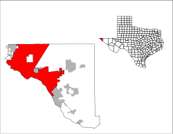 Upper right: El Paso County in Texas Left: Municipalities in El Paso County | |||||
| Position | |||||
El Paso, TX El Paso, TX | |||||
| Coordinates: 31 degrees 45 minutes 35 seconds north latitude 106 degrees 29 minutes 19 seconds west longitude / 31.75972 degrees north latitude 106.48861 degrees west longitude / 31.75972 degrees west longitude -106.48861 | |||||
| History | |||||
| establishment | 1680 | ||||
| administration | |||||
| country | |||||
| State | Texas | ||||
| county | El Paso County | ||||
| city | El Paso | ||||
| geography | |||||
| area | |||||
| City | 663.7 km2 (256.3 mi2) | ||||
| land | 661.1 km2 (255.3 mi2) | ||||
| water surface | 2.6 km2 (1.0 mi2) | ||||
| Elevation | 1,135 m (3,725 ft) | ||||
| population | |||||
| population | (as of 2010) | ||||
| City | 649,121 | ||||
| population density | 981.9 people/km2 (2,542.6 people/mi2) | ||||
| urban area | 804,123 | ||||
| Remarks | 19th largest population of U.S. cities | ||||
| Other | |||||
| equal time | Mountain Standard Time (UTC-7) | ||||
| daylight saving time | Mountain Daylight Time (UTC-6) | ||||
| Official website: https://www.elpasotexas.gov/ | |||||


The history of this area is old, and it is thought that ancient Native American had already settled there 10,000 years ago and agriculture was also practiced in the middle of the 12th century. In the 16th century, the settlement of Spanish people began, and in 1680, the Spanish built the Izureta Missionary Office. After the end of the Civil War, railways were opened one after another in El Paso, and mining and other industries developed, resulting in a rapid increase in population. Although the population decreased in the 1930s due to the damage of the Great Depression, it grew again in the mid-20th century due to the military expansion during and after World War II and the discovery of oil fields in neighboring areas. Today, El Paso has developed as a major trade hub with Mexico and an economic, medical, transportation, education and cultural center across a wide range of areas in western Texas and southern New Mexico.
History
As can be seen in the pinnacle of the Forsam culture, which was a hunter-gatherer society, excavated at the Fueco-Tanks State Park and a historic site in the northeast of today's El Paso City, it is thought that mankind had settled there long before Europeans settled there, about 10,000 years ago. Around 1150, agriculture was conducted using water from the Fueco Tanks, and crops such as corn, beans, pumpkins, and so on were produced. By the time the Spanish colonized the land in the 16th century, native Americans of the Manso, the Suma, and the Jumano had settled there. Later, these tribes were incorporated into the culture of Mesteisso with immigrants from central Mexico, prisoners of Comancelia, and slaves from various tribes called genízaro. They also settled in the Apache subfamily known as "Mescaleroa Patch."
The Spanish explorer Juan de Onjate, who was born in Sacatechas in 1550 (there is a theory that he was born in 1552) and was the first explorer of Nueva España in 1598 to survey the Rio Grande River near the present El Paso, celebrated the Thanksgiving Mass there on April 30, a few decades earlier than the Pilgrim Fathers. However, it is also thought that four survivors of the Panfilo de Nalbaez expedition to Florida (Albar Nunez Cabeza de Vaca, Alonso del Castillo Maldonado, Andrés Drántes de Caranza, and Estevanico) had already passed the area in the mid 1530s. In 1659, Frei Garcia de San Francisco founded El Paso del Norte (present Ciudad Juarez) on the south bank of the Rio Bravo de Norte (Rio Grande). In 1680, as a result of the Pueblo revolt, the temporary capital of New Mexico, Spanish territory, was established in El Paso, which was still a small village. After Spain occupied Santa Fe again in 1692, the capital of New Mexico was returned to Santa Fe. However, El Paso was the largest settlement in New Mexico until New Mexico was incorporated into the United States under the 1850 Agreement, and New Mexico was incorporated into Texas.
Since the percentage of Americans in the area was small and less than 10% of the total population, El Paso was not affected significantly during the Texas Independence War that broke out in 1836. However, as part of the postwar treaty between the Republic of Texas and Mexico, the Republic of Texas has tried several times to claim and strengthen its claim in the region. However, until the Texas rule was decisive in 1846, negotiations were held between Mexico and the Republic of Texas over the rule of the area, and El Paso and its surroundings were basically autonomous during this period.
The settlement of Americans in this area continued even during the period of Japan's dominion in 1836-48. In the middle of the 1840s, Spanish-affiliated settlements such as Rancho de Juan Maria Ponse de León, etc., had existed from ancient times, and in addition to these settlements, Anglo-Saxon settlers such as Simeon Hart and Hugh Stevenson, etc., had settled there for their loyalty to Texas. Stevenson, who married a daughter of a local Spanish aristocrat in 1844, founded the settlement of Rancho de San José de la Cordia, the core of the first Anglo-Saxon and Spanish settlement in the present El Paso. Considering the considerable amount of Santa Fe trade to develop the Texas Republic, the Guadalupe Idargo Treaty was effective in formally making the settlement on the north bank of the Rio Grande, separated from the Old El Paso del Norte on the Mexican side, the United States. Soon, the 1850 agreement led to the Texas-New Mexico border, which has El Paso on the Texas side, as it is today.
In March 1850, El Paso County was established and the first county office was established in San Elizario. The Federal Senate ruled the Texas New Mexico border at 32nd parallel north latitude, so history and terrain were little considered. In 1854, a garrison called "The Post opposite El Paso" was established. The settlement named Franklin, which was built in Coons Rancho to the west, later became the core of El Paso. The next year, Anson Mills completed the city's plan and named it El Paso. However, even if all the settlements that were created at that time were combined, there were only a few hundred people who were from the Anglo-Saxon and Spanish lines.
When the Civil War broke out, the area was placed under the control of the Southern Army. However, after the Northern Army's California army took control of the area in 1862, the headquarters of the Fifth Infantry Regiment of California was placed there until December 1864.
After the end of the Civil War, Americans continued to flow into the village and the population began to increase. The El Paso itself was incorporated in 1873 and included small settlements in the area that had developed along the river. Before long, when the Southern Pacific Railway, the Texas and Pacific Railway, and the Atchson Topika and Santa Fe Railway opened in 1881, the population rapidly increased, and in the census of 1890, the population of Japan exceeded 10,000, including the newly-introduced Mexican and Anglo-Saxon Lines, in addition to the old Spanish settlers. In addition to the conditions of the site, the new Arabs were brought in, making El Paso an illegal zone and known as Six Shooter Capital (the capital of six snipers) as a violent, violent, violent, and fast-growing town. Also, prostitution and gambling became popular and the situation continued until the Department of War put pressure on the city authorities during World War I. Due to these pressures and geographical conditions, the city eventually developed as an industrial, transportation and retail center in the southwestern United States of America.
In 1909, William Taft and Porfirio Díaz planned to hold a summit meeting in El Paso and Ciudad Juarez. The historic meeting was the first meeting between the Presidents of the United States and Mexico, and also the first ever visit Mexico across borders. However, tension between the two countries increased and the assassination notice was made, so the Texas Ranger, the U.S. and the Mexican Forces of 4,000 soldiers, the United States Secret Service, the Federal Bureau of Investigation, and the police were all mobilized to guard the Texas Ranger, the U.S. and the Mexican forces. Some of the guards at that time were Frederick Russell Burnham, who was later called the "father of scouting." Barnum was John Hayes Hammond, a close friend of Taft's since Yale University, who had invested a lot in Mexico. On Oct. 16, the day of the summit, Bernam and Texas Ranger C. R. Moore found a man with a small gun standing in front of the El Paso Commercial Office building on the march, and arrested him just a few feet before Taft and Diaz, disarmed him, and arrested him.
By 1910, most of the city's population was occupied by Americans. However, after the outbreak of the Mexican Revolution, in particular during the 1913-15 years, a large number of Mexican refugees, including priests, intellectuals and business men, came to the city. Before long, Mexican-affiliated refugees from the city built newspapers, theaters, movie theaters and schools in Spanish.
Soon, along with a large number of Mexican diaspora fleeing to El Paso, the violence of the Mexican Revolution has also spread to El Paso. In 1915, 16, and 17 years on end, Mexican revolutionary groups planned and carried out violent attacks against both Americans and Mexican political enemies in El Paso. In the midst of this, 21 white citizens were killed in a riot caused by the discovery of the San Diego Project. After that, retaliation by local militia put a toll on the violence, and 300 (estimated) Mexicans and Mexican Americans were killed. These disturbances affected almost all of the people in the lower reaches of the Rio Grande Valley, resulting in millions of dollars of damage and, for years to come, leaving a root problem between Americans and Mexicans in the area.
At the same time, American people began to flow into the city, and in 1920, the population of Japan, including the army's soldiers, exceeded 100,000, and white people became the majority again. On the other hand, the segregation of Mexicans and American and Mexican Americans in the city has advanced. In response to this, the Catholic Church sought to gain the loyalty of the Mexican-American community through education and through political and civic organizations such as the National Catholic Welfare Fund.
Mining and other industries gradually developed in this area. In 1897, the El Paso and Northeast Railway was launched to help mine natural resources in the surrounding area, especially in the southeastern part of the New Mexico Territory. In the 1920's and 1930's, commerce was developed by Shumiszo during the period of the Prohibition Act. However, the dissolution of the army, the agricultural economy recession and the subsequent Great Depression devastated the local economy of El Paso, and until the end of World War II, the population of El Paso, especially white people, continued to decline. Even so, until the 1940s, white people were the majority in El Paso's demographic structure.
The expansion of troops in this area during and after World War II and the discovery of oil fields in the Permian Basin to the east of El Paso led El Paso to rapidly develop economically in the mid-20th century. Smelting of copper, refining of oil, and development of low-wage industries (especially clothing) contributed to the growth of the city. In addition, the population at the periphery of the area, where many were white, was brought into urban areas like El Paso, and capital and workers grew rapidly. But at the same time, middle-class Americans flew out to other parts of the country in search of new, higher-paying jobs. Local industries, therefore, looked south in search of cheap Mexican workers. In addition, the Blacero Program involved the 1942-56 migration of Mexican laborers into the fringe of El Paso and filling the void left by the Caucus. Later, the Mexican workers also moved into El Paso in search of higher-paid jobs. In around 1965, the Hispanics became the majority of the population. On the other hand, the high growth after World War II slowed down in the 1960s, but the city continued to grow because of repeated incorporation of surrounding areas and significant economic relations with Mexico.
geography
El Paso is located at 31 degrees 45 minutes 35 seconds north latitude and 106 degrees 29 minutes 19 seconds west longitude. The city is located in the westernmost part of Texas, bordering the Rio Grande River, which borders New Mexico on the north and west and Mexico on the southwest, and bordering Chihuahua. Although it is a city in Texas, it is far west from the Texas triangle, which includes all five major cities of the state and has about 3/4 of the state population, and it is closer to Albuquerque in New Mexico (about 380km to the north) and Phoenix in Arizona (about 560km to the west-northwest) than Austin (about 850km to the southeast) and Dallas Fort Worth (about 900km to the northeast), and it is closer to San Diego (about 1,025km to the west) than Houston (about 1,080km to the east), and toward the west of Los Angeles (about 1,100 to the west), and toward the west of Los Angeles (225km). While other regions of the state belong to Central Standard Time/Daylight Time in equal times, only two counties of El Paso Hazpes, which belong to the El Paso Metropolitan Area, belong to Mountain Standard Time/Daylight Time Time as in New Mexico State.
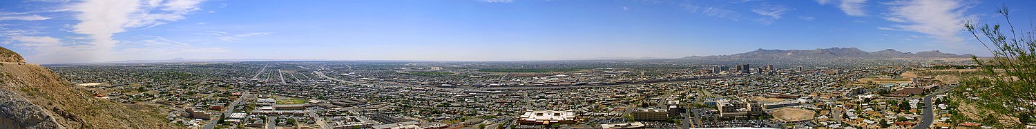
According to the United States Census Bureau, El Paso City has a total area of 663.7km2 (256.3mi2). Of them, 661.1km2 (255.3mi2) is land and 2.6km2 (1.0mi2) is the water area. The water area accounts for 0.39% of the total area. The city stretches over the northeastern shore of the Rio Grande River in the northern Chihua Desert, the most eastern part of Basin and Range. The Franklin Mountains form a chain of mountains to divide the city into two, and downtown areas have developed to the southernmost point. The altitude of downtown is 1,135m, the highest mountain in the Franklin Mountains, and the highest point in the city, North Franklin, is 2,192m above sea level.
The area of the metropolitan area combined with El Paso and Hazpes is 14,463km2(5,584mi2). Suburban cities in the El Paso metropolitan area extend from the southeast of the El Paso area along the Rio Grande River to Fort Hancock, the west end of the Huzpes County. Although some suburban cities, such as Sunland Park and Anthony, are formed in Donana County, New Mexico, and are located in the north and west of El Paso, although they are actually suburban cities of El Paso, they are, by definition, included in the urban area of Las Cruces, New Mexico, located approximately 70km north-northwest of El Paso. The Las Cruces metropolitan area is defined as the El Paso-Las Cruces metropolitan area along with the El Paso urban area.
climate
| El Paso | ||||||||||||||||||||||||||||||||||||||||||||||||||||||||||||
|---|---|---|---|---|---|---|---|---|---|---|---|---|---|---|---|---|---|---|---|---|---|---|---|---|---|---|---|---|---|---|---|---|---|---|---|---|---|---|---|---|---|---|---|---|---|---|---|---|---|---|---|---|---|---|---|---|---|---|---|---|
| Rain and Temperature (Description) | ||||||||||||||||||||||||||||||||||||||||||||||||||||||||||||
| ||||||||||||||||||||||||||||||||||||||||||||||||||||||||||||
| ||||||||||||||||||||||||||||||||||||||||||||||||||||||||||||
The climate of El Paso is characterized by a summer where it is dry throughout the year, hot during the day but cool at night, and a winter where it is cool during the day, although mild during the day, for its latitude, and has become a desert and highland climate where the difference between the temperatures and the day is large. The hottest July temperatures averaged about 35°C, while the lows dropped to an average of 21°C and the average temperature was about 28°C. The coldest January average temperature is 7°C and the average lowest temperature is 0.3°C below freezing, but during the day it is warm and rises to around 14°C. The amount of rainfall is much from July to September in the summer, which is about 35-40mm per month, but in the last three months it is more than half of the annual amount of rainfall. The other months are around 5-15mm per month. Annual rainfall is about 220mm. In winter, a slight snowfall is also seen.
According to the National Bureau of Meteorology, El Paso has a fair day of 302 days a year in normal times, which is why it is called The Sun City (the city of the sun). Because it is dry and windy, El Paso is particularly susceptible to sandstorms particularly from March to May in the spring season.
The rains of July and September are mainly brought by the North American monsoon. At this time of the year, wind from the south to the southeast brings moisture from the Pacific Ocean, the Gulf of California, and the Gulf of Mexico to El Paso and to various parts of the southwest. This wet wind rises on the slope of the mountain, and the heat of the day also generates a strong rising air current and cumulonimbus. This cumulonimbus causes thunderstorms and hail storms, which also causes floods. For example, from the end of July to the beginning of August 2006, the monsoon caused 250mm rains over the average year's amount of rainfall to fall a week, causing a massive flood throughout the city. In addition to the natural causes, the floods include the development of the arayo and the lack of facilities to handle the flooded rain water.
In the Keppen climate division, El Paso belongs to the Desert Climate (BW).
| Jan | Feb | March | April | May | June | July | August | September | Oct | November | Dec | Years | |
|---|---|---|---|---|---|---|---|---|---|---|---|---|---|
| Mean Temperature (°C) | 7.1 | 9.7 | 13.3 | 17.9 | 22.8 | 27.5 | 28.2 | 27.1 | 23.9 | 18.2 | 11.3 | 7.2 | 17.8 |
| Precipitation (mm) | 10.2 | 10.2 | 7.6 | 5.1 | 7.6 | 17.8 | 40.6 | 40.6 | 35.6 | 17.8 | 10.2 | 15.2 | 218.5 |
City Overview and Architecture
Left: Wells Fargo Plaza/Right: Plaza Hotel | ||
The downtown of El Paso is formed between the southern tip of the Franklin Mountains, the Rio Grande River, and although the number is small for the city's population, there are several skyscrapers. The tallest building in El Paso is the Wells Fargo Tower (22-story, 90.3m high), located at the northwest corner of North Kansas Street and Texas Street. This black skyscraper is known for its 13-story window lights (18 lights per east and west, 7 lights per north and south). On the Independence Day of July 4 every year, the Star-Sprung flag is drawn with this light. Also, at the time of the Iran-American Embassy hostage crisis in 1980 and the September 11, 2011 terrorist attacks, the Hojoban flag was drawn with the lights of the building. Other examples include a Christmas tree during Christmas time, and a letter of TEP, the abbreviation of the University of Texas, in support of the University of Texas.
The Wells Fargo Tower is followed by skyscrapers such as the Chase Tower (20-story, 85.3m high), the Kaiser Center (Stanton Tower, or 18-story, 79.1m high), and the Plaza Hotel (19-story, 72.9m high), the landmark of El Paso, which was built in 1930. The Plaza Hotel was the first hotel built by the Conrad Hilton founder. The Plaza Hotel was registered as a National Register of Historic Places in 1980 along with the 17-story, 65.5m-high Tower of Art Deco, also built in downtown 1930.
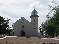
West Central El Paso, centered in the University of Texas and the Cincinnati Entertainment District, is located just northwest of the downtown. The historic district of Sunset Heights, where people began to live in the late 1890s, and Khan Place, built in the mid 1910s, are also included in West Central El Paso. In the north, at the western foot of the Franklin Mountains, North West El Paso (also called West Side or Upper Valley), where a relatively wealthy residential area is formed, spreads. At the eastern foot of the Franklin Mountains, a residential area developed in the 1950s and 1960s was built and is called North East El Paso. The area to the east of El Paso International Airport and to the north of I-10 is called East El Paso, and the residential area of the middle class is mainly spread. Mission Valley, which occupies the south (south of I-10) and southeast of East El Paso, is the longest-running district in the present-day El Paso, and remains the Izreta Mission Post (1680) built by Spanish settlers, the Sokolo Mission Post (1759), and the San Elizario Mission Post (1789). All of these missionary offices are registered as National Register of Historic Places.
politics
Under the City Charter approved and revised on February 7, 2004, El Paso adopted the City Manager system. The City Manager is the chief executive officer of the city's administration, and has the authority and responsibility for the personnel affairs of the city government, the management of the city's projects, the implementation of the policies adopted by the city council, and the preparation of the budget. The city council, on the other hand, has the authority and responsibility to appoint and command city managers, enact ordinances and policies, approve budgets and determine tax rates. The mayor serves as a representative of the city in a ceremonial place, and has the authority to attend the city assembly as a member of the city assembly and sign the resolution, but he has no authority and no responsibility for the administrative work. The city assembly consists of eight members, and each of them is selected from the eight-member constituency. The mayor is elected from all the cities, apart from the city councilors. The term of office is four years for both city councilors and mayors, and the number of elections is limited by two terms.
Texas is the largest Republican in the United States, but the Democratic Party of Japan (DPJ) prevails along the border with Mexico and in urban areas. Both El Paso City and El Paso County have their own characteristics, and the Democratic Party of Japan (DPJ) has a very strong power.
security
The Elpaso City Police, which protects the security of El Paso, are under the jurisdiction of the Deputy City Manager of Public Safety and Support Services, among three Deputy City Managers under the City Manager. In contrast to Ciudad Juarez, who was on the other side of the Rio Grande, who, after the 2000s, had experienced a sharp decline in security during the Mexican drug war, and who was once told that "the world's most dangerous place outside the war zone", El Paso's security was good. In a 2018 report (using FBI data in 2016) by Morgan Quitnot (CQ Press), the Tokyo Metropolitan Police Department reported that the incidence of violent crimes in El Paso is about 30% lower than the U.S. average and is the safest among cities with more than 500,000 people across the United States. However, on August 3, 2019, at Wal-Mart store located west of Sierra Vista Mall, south of El Paso International Airport, a shooting spree that seems to have aimed at the Hispanics occurred, killing 22 people (eight of them Mexican) and 24 seriously or slightly injured.
Economy
The regional economy of El Paso has diversified into many industries, including trade, military demand, oil and natural gas, medical care, tourism and services. Since the 2000s, El Paso has also become an important hub with a call center. In addition, the manufacturing industry has also been developed, producing petroleum products, metals, medical devices, plastics, machinery, munitions, and automotive parts.
El Paso is an oil refiner in Fortune 500, Western Refining (2017 rankings: 349th) and its subsidiary, Western Refining Logistics, had a head office. In June 2017, the parent company, Western Refining, was founded by San Antonio-based oil refiner Tesolo (current name: It was also proposed to acquire Western Refining Logistics, which was purchased by Andever. Helen of Troy Limited, a maker of home medical, beauty and nutritional supplement products, also has a U.S. headquarters in El Paso (although the registered headquarters is located in Hamilton, Bermuda Islands, Tax Haven). Local electric company El Paso Electric has been supplying electricity to western Texas and southern New Mexico, particularly its headquarters in El Paso.
In addition, Huber, Eureka, Boeing, Aptiv, and more than 70 companies in Fortune 500 have their bases in El Paso. According to the Hispanic Business Journal, El Paso has 28 headquarters, including Fred Royale, which ranks 500 of the largest Hispanic companies in the United States, after Miami's 57.
El Paso has Fort Bliss Army Base, Biggs Army Airport and William Beaumont Army Medical Center, which play a major role in the regional economy. The defense industry in El Paso employs more than 41,000 people and has an economic impact of more than $6 billion a year. In 2013, Fort Bliss Army Base was selected as a training center for the United States Air Force Guard, and two years later, from 2015, 8,000-10,000 members have been trained annually.
From its location along the border with Mexico, El Paso has several federal agencies that deal with the problems peculiar to the region. The El Paso-based organizations include the Seventh District of the DEA, the El Paso Information Center, the United Northern Task Force, the Border Guard, and the Border Guard Special Force.
The Call Center brings more than 10,000 jobs to El Paso. Thanks to its sunny climate, natural beauty, rich culture and history, and abundant outdoor activities, 2.3 million people visit El Paso every year, and the tourism industry has had an economic impact of $1.5 billion. The University of Texas at El Paso is also a big five-finger employer with more than 6,500 jobs in itself, and it has brought about the $1.3 billion annual economic benefits to El Paso.
medical care
El Paso is also the center of healthcare in western Texas and southern New Mexico. Major hospitals located in El Paso include William Beaumont Army Medical Center, Sierra Medical Center, Las Palmas Medical Center, Del Sol Medical Center, Sierra Providence East Medical Center, Herpaso Children's Hospital, Providence Memorial Hospital, etc. The American Medical Center, located east of downtown and northwest of the Mission Valley area, is a center of medical institutions such as Paul L. Foster Medical School of Texas University, its university medical center, Gale Glebe Hunt Nursing School of Texas University, El Paso Mental Medical Center, El Paso Children's Hospital, and the Cadwell Biomedical Research Institute, which opened in 2016. The University Medical Center is also the only level I trauma center in the area. In January 2017, Trans Mountain Hospital, a group of Providence Hospitals, was opened in the West El Paso district in cooperation with Paul L. Foster Medical School to serve as a university hospital for the school.
traffic
The airport, which serves as the gateway to El Paso, is located about 7.5km northeast of downtown El Paso's International Airport (IATA: ELP). The airport serves as the gateway not only to El Paso, but also to the western part of Texas and the southern part of New Mexico, including Las Cruces and Deming. The airport also includes Delta Air Lines (Atlanta), United Airlines (Houston Intercontinental, Denver), American Airlines (Dallas Fort Worth, Chicago O'Hare, Los Angeles, and Phoenix), Southwest Airlines from seven cities, Relative Air from Las Vegas and San Diego, and Frontier Air from Denver and Chicago O'Hare.
In the Rio Grande River, the border with Mexico, in the middle of the 18th century, in the era of Nueva Espana, a bridge of wood from Santa Fe was already built. At present, the following four bridges are constructed in order from the upstream.
- Paso del Norte International Bridge
- Good Neighbor International Bridge
- Cordoba Bridge
- Isleta-Saragoza International Bridge
The interstate expressway, I-10, runs just north of the downtown. I-10 is a trunk line that runs east-west through southwestern and southeast and connects Los Angeles and Jacksonville, Florida, across the continent and connects El Paso with San Antonio and Houston even in Texas. It also diverges to I-25 to the south of Las Cruces, and I-10 goes to Deming, Tucson and Phoenix, and I-25 goes to Albuquerque and Denver, respectively. It also diverges to 270km in the east of El Paso and I-20 in Reeves County, leading to Midland Odessa, Abilene and Dallas Fort Worth. I-110, a branch of I-10, branches south from the main line at the east of downtown and connects with National Route 45 at the Americas Bridge. In addition, National Route 54 is an expressway standard in El Paso City, and it is a radiation that runs through North East El Paso and joins and branches into I-10. Route 375 also features a U.S.-shaped U.S. route that runs downstream from the south of the downtown area along the Rio Grande Riverbank, passes through Mission Valley, East El Paso and North East El Paso, runs through the Franklin Mountains and joins and diverges to I-10 at North West El Paso, and serves as the El Paso's loop.
The Greyhound bus terminal is located at two locations, downtown and at the north end of Paso del Norte International Bridge, the latter being called the El Paso Santa Fe Bus Station to distinguish it. The El Paso Santa Fe Bus Station is the starting and ending point for buses bound for Albuquerque and Denver. The bus stops at the downtown terminal, and the bus that connects Los Angeles, Phoenix, San Antonio, and Dallas Fort Worth stops.
At Union Depot in downtown, the long-distance train of Amtruck between Los Angeles and New Orleans, the Sunset Limited, and the train in the west of San Antonio, the Texas Eagle, which secures at San Antonio and runs north to Chicago, stops at three stops a week for Los Angeles and New Orleans and Chicago. Union Depot is a historical building built in 1906 and was registered as a National Register of Historic Places in 1975.
For public transportation in the city, route buses are operated by San Metro. The bus network of the Bureau has Local Route 50 and Express Route 12, covering Sanland Park, New Mexico, in addition to the areas within the city and El Paso County. Sun Metro has also raised $97 million from the Texas State Transportation Bureau and is building streetcars in mid-2018 to start operations. In addition, in 2009, the New Mexico State Transportation Bureau began operating a commuter bus that connects El Paso and Las Cruces. The New Mexico Bureau of Regional and Transportation for the South-Central Area of New Mexico has been promoting the research of the four bus routes connecting El Paso and Las Creuse and the suburbs of both cities since 2016, as well as the proposed commuter train connecting the two cities.
education
The University of Texas, El Paso (TEP) has a 420-acre (1,700,000m2) campus, just northwest of the downtown, with buildings reminiscent of Bhutanese. The school was established in 1914 as a state university, and after working at Texas Mining Metal University and Texas Western University, it was incorporated into the University of Texas system in 1967 and renamed as Texas University System. The school has eight faculties, including liberal arts, management, education, engineering, health sciences, science, nursing, and pharmacy, and it has 72 departments, 74 master graduate courses, and 21 doctoral programs with about 24,000 students. Among them, the Faculty of Engineering has produced the largest number of Hispanic masters and doctoral engineers in the United States. Minors, a sports team from the school, belongs to the Conference USA belonging to NCAA Division I (football is FBS Group 5/former I-A non-BCS) and is competing for five boys and nine girls. In 1966, the school's men's basketball team won the U.S. National Title by appointing all the first five African-style players to the top-ranking Kentucky University in the NCAA Tournament finals held at College Park in Maryland. With this game as a turning point, Japanese athletes from African descent began to be actively recruited to follow other universities in the south, ending the era of racial segregation in the competition. The autobiography of Don Haskins, the head coach of the time who wrote the season to the match, was later made into a movie in 2006 as "Glory Road" starring James Gartner and Josh Lucas. In the following year, 2007, the team entered the basketball hall of fame.
The Texas Institute of Technology has a health science center, El Paso, in El Paso. The New Mexico State University also applies tuition to civil-rights students in the United States of Texas within 135 miles (217 km) from the main campus of Las Cruces, and many of them are from El Paso, who go on to study there using this.
The K-12 program in El Paso is supported mainly by the El Paso Independent School District, Izreta Independent School District, Sokolo Independent School District, and public schools under the jurisdiction of the Canutillo Independent School District. The El Paso Independent School District has 57 elementary schools, 15 junior high schools and 11 high schools and has about 60,000 children and students.
The El Paso Public Library has a branch in 10 locations in the city as well as the main building in downtown. In addition, the library's mobile library has set up two weekly routes to travel around the city. The El Paso Community College also has a public library with the name of Laura Bush and his mother Jenna Welch, located on the Northwest Campus, one of five campuses in the city.
culture
Museums and art museums
The Herpaso Museum of Archeology is located at the eastern foot of Mt. North Franklin and along State Route 375. The museum mainly stores and exhibits artifacts such as earthen vessels and baskets by the Pueblo, Asabasca, and Tarahumara clans in the southwestern United States and northern Mexico in the prehistoric period. The museum exhibits dioramas related to the region's geology and culture, including the Fueco Tanks and the Kueva de la Oja (Cueva de la Olla, a cave of earthenware). In the 15 acres (60,700m2) of the museum, a garden and a promenade are built to grow and exhibit over 250 kinds of plants from the Chihuahua Desert. Next to the Herpaso Archeological Museum, there is the National Border Guard Museum, which is the only museum in the United States concerning border guards and their history.
The History Museum of El Paso, located in downtown Tokyo, has permanent exhibits on things related to the early El Paso. Two blocks north of the El Paso Museum of History, across I-10, lies the El Paso Holocaust Museum and Research Center. The museum is one of the survivors of the Holocaust, and was established by Henry Kellen, a Lithuanian and Jewish immigrant who came to El Paso after the end of World War II, to show things about the Holocaust that he learned about the existence of the Holocaust denial theory in the 1980s and collected against it as a place for peace education. Two blocks south of the Herpaso Museum of History is located there. The museum houses and permanently exhibits works of European art from the 13th to 18th centuries, Mexican art from the 17th to 19th centuries, American art from the 19th century, and modern and contemporary art from the latter half of the 20th century and later, mainly in the area along the border between Texas and the United States and Mexico in the southwestern area.
On the campus of the University of Texas, El Paso, there is the 100th Anniversary Museum, Chihuahua Desert Botanical Garden, which, as its name suggests, is built to commemorate the 100th anniversary of the independence of Texas and exhibits cultural and natural history in the Chihuahua Desert area. In the northeastern part of the downtown area, there is an International Museum of Art, which was converted into an art museum by a widow who donated a Victorian-style mansion, which was then a state senator in the early 20th century, to the city after her death. The museum is permanently exhibiting works of art in Africa, Asia and Mexico, including works of William Colicar, a native of El Paso, and works of artists from other southwestern areas. Magofin Homestead State Historic Site, also located in the northeast of downtown, preserves Spanish colonial-style houses built in 1875, and is open to the public as a museum, as well as being rented out for general events. Magofin Homestead was registered as a National Register of Historic Places in 1971.
stage art
The Plaza Theater is located in downtown and east of the El Paso Museum. Built in 1930 and remodeled in 2006, the museum has a main theater with 2,060 seats and a philanthropic theater with 200 seats. A musical by Broadway and a performance by the El Paso Symphony Orchestra, a local orchestra, are also performed. It is also one of the most famous landmarks in El Paso. The Plaza Theater was registered as a National Register of Historic Places in 1987.
The Abraham Chavez Theater, with 2,500 seats in a sombrero-style appearance, is located in the southeast of the El Paso Convention Center in the west of the Herpaso Museum. The El Paso Playhouse, which has the longest history in El Paso, is located on the Montana Avenue, about three kilometers northeast of downtown. The theater is affiliated with Kids N Co, a theater for children. The University of Texas, El Paso, will also have a Dinner Theater located on its campus.
In the valley surrounded by rock walls in three directions in the mountains of Franklin, there is the McKelligon Canyon Outdoor Theater with 1,500 seats. In this outdoor theater, a musical, "Viva!" is an annual event in El Paso's 400-year history and culture, as well as concerts. A performance of "El Paso" will be held.
Several music festivals are also held. In the middle of March every year, a Texas Showdown Festival, a tattoo and rock festival, is held for three days. At the last weekend of May every year, a neon desert music festival is held in downtown. At the El Paso Convention Center, the El Paso Downtown Street Festival is held every year at the end of June. Every year from June to July, a music festival called Music under the Stars is held at Cohen Stadium, which used to be the home of El Paso Diablos Co., Ltd., and performs a wide range of genres, ranging from classical to country, to tehano, to rock. On the first weekend of September every year, an electronic dance music event called the City Music Festival is held.
sport
There are no North American four major professional sports leagues in El Paso, but there are minor league teams. El Paso Chihuawas, a AAA-grade team under San Diego Padres, moved from Tucson, Arizona, in 2014, belongs to the Pacific Coast League. Although the history of El Paso is short, the origin of the team goes back to the Los Angeles Angels established in 1903. To attract the Chihuahad, the city demolished the city hall to make it the home ground of the team, and as part of the downtown redevelopment project to build a baseball park called Southwest University Park on the site. Before that, there was an independent league baseball team called El Paso Diabroz, which had been running since the 1890s. The team belonged to the American Association and was based in Cohen Stadium in Northeast El Paso, but it disappeared in 2013 in place of Chihuahuaze.
And El Paso is a place where the Sun Bowl is held every year, one of the Bowl games held in various parts of the United States at the end of the New Year. Although this bowl game is not called the New Year's Six (or the "Six Major Bowls") under the College Football Playoffs System, it has a long history among the bowl games, which started as a local high school game in 1935 when the Orange Bowl and the Sugar Bowl were first held, and started as a college football bowl game in 1936. The Sun Bowl Stadium, where the Sun Bowl is held, is located on the campus of the University of Texas El Paso, and is also used as the home ground of the football team of the Minors.
And like the southwestern and mountainous regions, the traditional sport in El Paso is Rodeo. At the beginning of June every year, a rodeo event called South Western International PRCA Rodeo is held in Coliseum, El Paso County, located east of downtown and southeast of the junction on National Route 62 and I-110. It is the 17th longest-running U.S.-Japan Professional Rodeo Cowboy Association (PRCA) event in the world and is expected to be among the top 50 U.S. by the association.
KLAQ, a local FM radio station, hosts the Kayak, Canoe and Rafting races, called the KLAQ Great River Raft Race, in the area of about five kilometers north-west of the Rio Grande River, in late June every year.
Events
The Amigo Air Show, an air show held at the Big Z Army Airport every autumn, was one of the major events in El Paso. However, the club was forced to cancel the meeting in 2013 on the grounds of the degeneration of the federal budget, and in the following year, 2014, it moved to the International Jet Port in Donyana County, Santa Teresa, New Mexico State in the west suburb, and was held on a smaller scale. Furthermore, it has not been held since 2015, the following year.
Fiesta de las Flores, organized by the El Paso-Hispanic Cultural Center, is the longest-running Hispanic festival in the southwestern region. The event, held every year for three days on the weekend of Labor Day, holds events such as a parade and a dance, and has more than 80 stalls. The event attracts customers not only from El Paso, but also from western Texas, southern New Mexico, Albuquerque and Chihuahua, Mexico, across the border, attracting 20,000-30,000 people each year.
On the weekend of Memorial Day every year, a hot balloon event called KLAQ El Paso Balloon Festa was held. Like the Great River Raft Race above, the KLAQ-sponsored event had a rock concert on the ground in addition to the hot air balloon. However, it was difficult to hold the event because it was close to the air traffic control area defined by the national border and the Federal Aviation Administration, because of its mountainous terrain, and the crowds of cacti on the surface of the earth, and was canceled in 2017. KLAQ has indicated that it will reschedule the event after 2018 by changing its dates and locations.
Parks and recreation
The Franklin Mountains, which divide the northern part of the city into two, are designated as state parks. The Franklin Mountains State Park is the largest urban park in the United States with 27,000 acres (109km2) in size. In the park, there are paved walkways that exceed 100 miles (161 km) in total for hiking and mountain motorcycles, and there are also places where camping is possible in tents and RVs. From the east slope (that is, the most downtown) in the south of the park, Willer Air Real Tramway leads to the Ranger Peak Peak at 1,717m. The ropeway is 792m long and 287m high above sea level, and it connects the base and the top in four minutes.
The Fueco Tanks State Historic Site and Park are located about 50km northeast of the city. The park is a place of cultural and spiritual importance for Native Americans, as seen in the murals painted by ancient Native Americans who lived there over 10,000 years ago, as well as in the recreational activities of bird watching and boldling. In the east of the downtown area, the Chimisal National Memorial Park, 54.9 acres (222,000m2), is located in the southwest of the junction of I-110 and National Route 62. The park is not only a city park, but also a city park that tells the history of the 100-year conflict between the United States and Mexico border and conveys both cultures. The park has a visitor center with a detailed museum of the border history, an art gallery, a theater and an outdoor theater.
The El Paso Zoo is located in the northeast of the junction on I-110 and National Route 62. The 35 acres (142,000m2) of the park is largely divided into three zones, Asia, Africa and North and South America, and more than 220 animals are kept there.
There are more than 250 parks in El Paso managed by the City Government's Park and Recreation Agency, covering a total of 3,000 acres (12km2).
loose character
In El Paso there is a character called Amigo Man. The character, with a smiling sun and a sombrero on the head and a cowboy boot on the foot, was created by the El Paso Convention and Tourism Board in 1974 for marketing in the city. In 1999, Amigoman temporarily retired but was revived in 2006 at the strong request of local residents. Amigoman can attend events such as the Sun Bowl to promote the city, as well as call corporate and personal events. The public is accepting the invitation of those who enter into Amigoman's Kigurumi, and it is required that they be over high school graduates, that they are 5 feet 6 inches (167.6 centimeters) tall and 5 feet 10 inches (177.8 centimeters) tall due to limitations on the size of the Hagumi, and that they can endure the fierce heat of El Paso during the summer.
religion
About 60% of El Paso people believe in any religion, which is higher than 49.4% of the U.S. and 57.6% of the Texas state as a whole. Catholics account for about 3/4 of the total population and about 45% of the city's population, which is very high compared with 19.7% of the U.S. Meanwhile, Texas has a Baptist population of 16.3%, almost twice the national figure of 8.2%, while Texas is a minority in El Paso with only 3.5%.
El Paso has a Roman Catholic diocese. Founded in 1914, the Diocese is one of the seven Diocese under the jurisdiction of the Archbishop of San Antonio, which has jurisdiction over 10 counties of western Texas, including El Paso. The Catholic Diocese is based in the cathedral of St. Patrick, located north of the downtown and southeast of the University of Texas at El Paso. The diocese also owns and manages the three historical missions of Izleta, Sokoro and San Elizario as mentioned above.
demographic dynamics
urban population
The population of each of the counties that form the metropolitan area and the metropolitan area of El Paso is as follows (2010 census)
- El Paso metro
| county | State | population |
|---|---|---|
| El Paso County | Texas | 800,647 |
| Haspes County | Texas | 3,476 |
| Total | 804,123 | |
- El Paso Las Cruces Metropolitan Area
| Metropolitan/Small Metropolitan Area | county | State | population |
|---|---|---|---|
| El Paso metro | 804,123 | ||
| Las Cruces Metropolitan Area | Donyana County | New Mexico | 209,233 |
| Total | 1,013,356 | ||
urban population transition
Below is a graph and chart showing the population transition from 1880 to 2010 in El Paso.
| statistical year | population | rank |
|---|---|---|
| 1880 | 736 | - |
| 1890 | 10,338 | - |
| 1900 | 15,906 | - |
| 1910 | 39,279 | - |
| 1920 | 77,560 | 89th |
| 1930 | 102,421 | 86th |
| 1940 | 96,810 | 98th place |
| 1950 | 130,485 | 76th |
| 1960 | 276,687 | 46th |
| 1970 | 322,261 | 45th |
| 1980 | 425,259 | 28th |
| 1990 | 515,342 | 22nd place |
| 2000 | 563,662 | 23rd place |
| 2010 | 649,121 | 19th |
sister city
El Paso has established a sister-city relationship with the following cities:
Hadra (Israel)
reference literature
- Hammond, John Hays. The Autobiography of John Hays Hammond. New York: Farrar & Rinehart. 1935 ISBN 978-0-405-05913-1.
- Hampton, Benjamin B. "The Vast Riches of Alaska". Hampton's Magazine. Vol.24. Issue 1. April 1, 1910.
- Harris, Charles H. III. and Louis R. Sadler. The Secret War in El Paso: Mexican Revolutionary Intrigue, 1906-1920. Albuquerque, New Mexico: University of New Mexico Press. 2009 ISBN 978-0-8263-4652-0.
- Harris, Charles H. III and Louis R. Sadler. The Texas Rangers And The Mexican Revolution: The Bloodiest Decade. 1910-1920. Albuquerque, New Mexico: University of New Mexico Press. 2004 ISBN 0-8263-3483-0.
- "Mr. Taft's Peril; Reported Plot to Kill Two Presidents". London: Daily Mail. October 16, 1909. ISSN 0307-7578.
Notes
- ^ a b c d American FactFinder. U.S. Census Bureau. February 4, 2011.
- ^ Hueco Tanks State Park & Historic Site: History. Texas Parks and Wildlife. Read January 5, 2018.
- ^ Metz, Leon C. El Paso Chronicles: A Record of Historical Events in El Paso, Texas. El Paso: Mangan Press. 1993 ISBN 0-930208-32-3.
- ^ Sumner, Mark. America, the artifact. Daily KOS. June 30, 2011. Read January 5, 2018.
- ^ Timmons, Wilbert H. El Paso, A Borderlands History. pp.74-75. University of Texas at El Paso. 1990 ISBN 9780874042078.
- ^ a b c El Paso, Texas. Handbook of Texas. Texas State Historical Association. Read on January 11, 2018.
- ^ Orton, Richard H. Records of California Men in the War of the Rebellion 1861 to 1867. p.672. Sacramento: Adjutant General's Office, State of California. 1890
- ^ Harris (2009), p.1.
- ^ Harris (2009), p.15.
- ^ Hampton.
- ^ Daily Mail, p.7.
- ^ Harris (2009), p.16.
- ^ Hammond, pp.565-566.
- ^ Harris (2009), p.213.
- ^ Harris (2004), p.26.
- ^ Plan of San Diego. Handbook of Texas. Texas State Historical Association. Read on January 17, 2018.
- ^ Macías-González, Víctor M. Mexicans "of the better class": The elite culture and ideology of Porfirian Chihuahua and its influence on the Mexican American generation, 1876-1936. University of Texas at El Paso. 1995
- ^ Texas Triangle. America 2050. Read on January 21, 2018.
- ^ OMB BULLETIN NO. 15-01: Revised Delineations of Metropolitan Statistical Areas, Micropolitan Statistical Areas, and Combined Statistical Areas, and Guidance on Uses of the Delineations of These Areas. Office of Management and Budget. July 15, 2015.
- ^ a b Historical Weather for El Paso, Texas, United States of America. Weatherbase.com. Read on January 22, 2018.
- ^ Rincón, Carlos A. "Solving Transboundary Air Quality Problems in the Paso Del Norte Region". Both Sides of the Border. Ed. Linda Fernandez and Richard Carson. Springer. 2002 ISBN 1-4020-7126-4.
- ^ Rogash, J., M. Hardiman, D. Novlan, T. Brice, and V. MacBlain. Meteorological Aspects of the 2006 El Paso Texas Metropolitan Area Floods. Santa Teresa, New Mexico/El Paso, Texas: NOAA/National Weather Service, Weather Forecast Office.
- ^ Wells Fargo Plaza. Emporis. Viewed on February 3, 2018.
- ^ Chase Tower. Emporis. Viewed on February 3, 2018.
- ^ Stanton Tower. Emporis. Viewed on February 3, 2018.
- ^ Plaza Hotel. Emporis. Viewed on February 3, 2018.
- ^ Aloft El Paso Downtown. Emporis. Viewed on February 3, 2018.
- ^ a b c d e TEXAS - El Paso County. National Register of Historic Places. Viewed on February 3, 2018.
- ^ a b Manning, Patrick. El Paso's City Hall Demolished, Making Way For New Ballpark, Revitalization. FOX News. April 15, 2013. Viewed on February 8, 2018.
- ^ City Form of Government. City of El Paso. Viewed on February 8, 2018.
- ^ Powers and Duties of the Mayor. City of El Paso. Viewed on February 8, 2018.
- ^ City of El Paso Representative Districts. City of El Paso. Viewed on February 8, 2018.
- ^ Resolution Canvassing Results of the 2004 City Charter Amendment Election And Declaring Adoption To Amendments of City Charter. p.2. City of El Paso. February 7, 2004. Viewed on February 8, 2018.
- ^ Maxwell, William Earl, Ernest Crain, and Edwin S. Davis. Texas Politics Today. Thomson Wadsworth. 2005 ISBN 0-534-60211-8.
- ^ Organizational Chart. City of El Paso. Viewed on February 9, 2018.
- ^ Olsen, Lise. Ciudad Juárez passes 2,000 homicides in '09, setting record. Houston Chronicle. October 21, 2009. Viewed on February 9, 2018.
- ^ Crime Rate Rankings (City). CQ Press, SAGE Publications. 2018 Viewed on February 9, 2018.
- ^ Hutchinson, Bill, Aaron Katersky, and Josh Margolin. Alleged shooter cased El Paso Walmart before rampage that killed 22: Law enforcement officials. ABC. August 5, 2019. Viewed on August 6, 2019.
- ^ Western Refining. Fortune 500. Fortune. 2017 Viewed on February 24, 2018.
- ^ Gray, Robert. Tesoro completes $6B acquisition of Western Refining: El Paso loses publicly traded company headquarters. El Paso Inc. June 5, 2017. Viewed on February 24, 2018.
- ^ a b El Paso: Economy - Major Industries and Commercial Activity. City-Data.com. Viewed on February 24, 2018.
- ^ "El Paso's 28 companies second in nation for Hispanic Business 500". El Paso Times. July 30, 2013.
- ^ Ramirez, Cindy. "Fort Bliss, Beaumont infuse $6 billion into El Paso economy". El Paso Times. March 8, 2013.
- ^ Rodriguez, Ashlie. "U.S. Air Force chooses Ft. Bliss for training center". KVIA. June 27, 2013.
- ^ Convention and Tourism Highlights - City of El Paso FY2013 Manager's Proposed Budget. (Archive) p.7. El Paso Convention & Visitor's Bureau. July 19, 2012.
- ^ $1.3 Billion Added to Local Economy Each Year. University of Texas at El Paso. Viewed on February 24, 2018.
- ^ About Us. University Medical Center of El Paso. Viewed on February 25, 2018.
- ^ Trauma Center Level. American College of Sergeon. 1998 Qtd by Khon Kaen Regional Hospital.
The trauma center is a facility that provides emergency medical care to patients with trauma, and is rated in four stages from level I to level IV. The Level I trauma center serves as the center of the area's trauma emergency medical care, and serves as the center for prevention of trauma, rehabilitation after healing, human resource development of trauma emergency medical care, research on trauma emergency medical care, and construction and planning of an trauma emergency medical system. - ^ Transmountain Campus. Hospitals of Providence. Viewed on February 25, 2018.
- ^ Flores, Aileen B. New West Side teaching hospital to open Jan. 17. El Paso Times. January 4, 2017. Viewed on February 25, 2018.
- ^ El Paso Int'l. (Form 5010) Airport Master Record. Federal Aviation Administration. February 1, 2018. Read on February 17, 2018.
- ^ Airlines. El Paso International Airport. Read on February 17, 2018.
In addition, the Dallas Flight of Southwest Airlines arrives at and departs from Labfield and Houston Flight, Hobby, respectively. - ^ Horgan, Paul. Great River: The Rio Grande in North American History. Volume 1, Indians and Spain. Vol. 2, Mexico and the United States. Wesleyan University Press. 4th Reprint. 1991 ISBN 0-8195-6251-3.
- ^ El Paso Bus Station. Greyhound. Read on February 17, 2018.
- ^ El Paso Santa Fe Bus Station. Greyhound. Read on February 17, 2018.
- ^ Sunset Limited. p.1. Amtrak. November 5, 2017. Read on February 17, 2018.
Although the Sunset Limited was originally a transcontinental train connecting Los Angeles and Orlando, due to the influence of Hurricane Katrina and Hurricane Rita in 2005, it was permanently operated only in the section west of New Orleans. There is no prospect of restoration beyond New Orleans. - ^ Texas Eagle. p.1. Amtrak. November 5, 2017. Read on February 17, 2018.
The Texas Eagle operates daily between Chicago and San Antonio, and it is operated independently with San Antonio as its starting point and terminal point except during the operation day of the Sunset Limited. - ^ Routes and Schedules, Bus System Map. Sun Metro. Read February 17, 2018
- ^ El Paso streetcar project on schedule, on budget. El Paso Proud. October 6, 2016. Read on February 17, 2018.
- ^ UPDATED: Las Cruces-El Paso Commuter Bus Service Begins. Albuquerque Journal. September 1, 2009. Read February 17, 2018
- ^ Bus Service Linking Las Cruces to Rural Areas/El Paso Begins Feb. 22. Doña Ana County. February 17, 2016. Read on February 17, 2018.
- ^ All Lines. South Central Regional Transit. Read on February 17, 2018.
- ^ Passenger Rail. South Central Regional Transit. Read on February 17, 2018.
- ^ About UTEP. University of Texas at El Paso. Read on February 18, 2018.
- ^ UTEP tops national rankings for producing Hispanic engineers. The University of Texas System. April 3, 2013. Read on February 18, 2018.
- ^ UTEP Miners Home. University of Texas at El Paso. Read on February 18, 2018.
- ^ UTEP Celebrates 50th Anniversary of Historic 1966 NCAA Championship Win. University of Texas at El Paso. Read on February 18, 2018.
- ^ 1966: Texas Western defeats Kentucky in NCAA finals. This Day in History Mar 19. HISTORY. Read on February 18, 2018.
- ^ 1966 Texas Western. Naismith Memorial Basketball Hall of Fame. Read on February 18, 2018.
- ^ Home. Texas Tech University System. Read on February 18, 2018.
- ^ El Paso Resident Tuition. New Mexico State University. Read on February 18, 2018.
- ^ Overview. El Paso Independent School District. Read on February 18, 2018.
- ^ Main Library. El Paso Public Library. Read on February 18, 2018.
- ^ Bookmobile. El Paso Public Library. Read on February 18, 2018.
- ^ The Jenna Welch and Laura Bush Community Library. El Paso Community College. Read on February 18, 2018.
- ^ Collections. El Paso Museum of Archaeology. Read on March 4, 2018.
- ^ Noble, John. Mexico. p.365. Lonely Planet. 2008 ISBN 9781741048049.
- ^ Chihuahuan Desert Garden and Nature Trails. El Paso Museum of Archaeology. Read on March 4, 2018.
- ^ Home. National Border Patrol Museum. Read on March 4, 2018.
- ^ Exhibits. El Paso Museum of History. Read on March 4, 2018.
- ^ About the Founder, Henry Kellen. El Paso Holocaust Museum and Study Center. Read on March 4, 2018.
- ^ Collections, European, Mexican, American, Modern & Contemporary. El Paso Museum of Art. Read on March 4, 2018.
- ^ Centennial Museum and Chihuahuan Desert Gardens. University of Texas at El Paso. Read on March 4, 2018.
- ^ Home. International Museum of Art. Read on March 4, 2018.
- ^ Collections. International Museum of Art. Read on March 4, 2018.
- ^ Magoffin Home State Historic Site. Texas Historical Commission. Read on March 4, 2018.
- ^ Plaza Theatre. El Paso Live.com, March 10, 2018.
- ^ Freuently Asked Questions. El Paso Symphony Orchestra. Read on March 10, 2018.
- ^ Natividad, Maria Almeida. Famous Places in El Paso History: A Bilingual Picture and Activity Book. p.33. El Paso, Texas: Galeria del Sol. 2015 ISBN 9780986184307.
- ^ Abraham Chavez Theatre. El Paso Live.com, March 10, 2018.
- ^ Home. El Paso Playhouse. Read on March 10, 2018.
- ^ UTEP Dinner Theatre. University of Texas at El Paso. Read on March 10, 2018.
- ^ McKelligon Canyon Amphitheatre. El Paso Live.com, March 10, 2018.
- ^ Home. Viva! El Paso. An El Paso Community Foundation Project. Read on March 10, 2018.
- ^ Home. Neon Desert Music Festival. Scoremore Shows. Read on March 17, 2018.
- ^ Home. El Paso Downtown Festival. Townsquare Media. Read on March 17, 2018.
- ^ GECU Presents Music Under the Stars. El Paso Live.com, March 18, 2018.
- ^ Home. Sun City Music Festival. Disco Donnie Presents. Read on March 17, 2018.
- ^ Espinosa, Lizette. El Paso Diablos Close Out Era Tonight. August 25, 2013. Read on March 17, 2018.
- ^ Legends of the Sun Bowl: Ken Heineman. Sun Bowl. Read on March 11, 2018.
- ^ Southwestern International Prca Rodeo. Rodeos USA. Read on March 18, 2018.
- ^ KLAQ's Great River Raft Race. KLAQ. June 22, 2013. Read on March 18, 2018.
- ^ Editorial: Amigo Airsho future is very much in doubt. El Paso Times. August 12, 2015. Read on March 18, 2018.
- ^ Fiesta de las Flores. El Paso: Hispanic Cultural Center. Read on March 18, 2018.
- ^ KLAQ Balloonfest Likely Postponed Until 2018. KLAQ. April 10, 2017. Read on March 18, 2018.
- ^ 2017's KLAQ El Paso BalloonFest canceled. KVIA, ABC. April 13, 2017. Read on March 18, 2018.
- ^ a b Franklin Mountains State Park. Parks and Wildlife Department, State of Texas. Read on March 20, 2018.
- ^ Things To Do: Franklin Mountains State Park. Visit El Paso. Read on March 20, 2018.
- ^ Wyler Aerial Tramway. Parks and Wildlife Department, State of Texas. Read on March 20, 2018.
- ^ Mulvihill, K. On Rock Walls, Painted Prayers to Rain Gods. New York Times. September 19, 2008. Read on March 20, 2018.
- ^ Chamizal: Where History and Culture Come to Life. National Park Service. Read on March 20, 2018.
- ^ Visit the Zoo, Interactive Map. El Paso Zoo. Read on March 20, 2018.
- ^ Parks. City of El Paso. Read on March 20, 2018.
- ^ a b Amigo (Sun) Man - El Paso, Texas. El Paso Museum of History. October 31, 2017. Read April 1, 2018.
- ^ a b c Amigo Man To Present City As Grand Marshall In Sun Bowl Parade. KVIA. November 23, 2010. Read April 1, 2018.
- ^ a b c Ramirez, Cindy. El Paso has job opening for new Amigo Man; mascot must have sunny disposition. El Paso Times. March 7, 2018. Read April 1, 2018.
- ^ Amigo Man. Visit El Paso. Read April 1, 2018.
- ^ El Paso, Texas. Sperling's Best Places. Read April 1, 2018.
- ^ Quick Facts. Diocese of El Paso. Read April 1, 2018.
- ^ St. Patrick's Cathedral. Diocese of El Paso. Read April 1, 2018.
- ^ Historic Missions. Diocese of El Paso. Read April 1, 2018.
- ^ Gibson, Campbell. Population of the 100 Largest Cities and Other Urban Places in the United States: 1790 to 1990. US Census Bureau. 2005
- ^ El Paso Texas and Hadera Israel - Sister Cities and a New Economic Alliance. Israel Trade and Economic Office. May 22, 2015. Read on January 22, 2018.
external link
- City of El Paso Website
- Chamber of Commerce Website
- El Paso Developmental News
- El Paso, Texas - City-Data.com
Coordinates: 31 degrees 45 minutes 35 seconds north latitude 106 degrees 29 minutes 19 seconds west longitude / 31.759722 degrees north latitude 106.488611 degrees west longitude / 31.759722 degrees west longitude -106.488611